A map of Lake Victoria, in a traditional atlas style
Maps
My own attempt at making an atlas-style map showing the political boundaries and elevation of Kenya, Tanzania, and Uganda
A few years ago I started a part-time master’s degree in geographical information science at Sweden’s Lund University. In my second year, as the final assignment for the Advanced GIS course, we eager students were given a pile of geographical data centred on Lake Victoria — political boundaries, terrain, water bodies — and asked to make a map. It was up to each of us what type map to make exactly, so I decided to have fun with it and try to make a traditional atlas-style map of the area. I was really happy with how it came out, and I’ve finally got around to publishing it here.
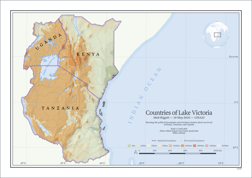
I did my best to include all the necessary pieces for a good atlas map — local projection, lines of longitude and latitude, north arrow, scale bar, inset globe map — along with the sort of aesthetic choices you often see in atlases — serif fonts, traditional terrain colours, a coastline ‘glow’, text that arcs across the map. That sort of thing. The base map was made in QGIS, which I then imported in to Affinity Publisher and added most of the artistic touches. (If you want to see the original high-res PDF, click the image above.)
I was especially happy with how the hillshading came out. It was a fairly intricate process to make, but the short answer is that I used a terrain DEM to make two layers, a multidirectional hillshade layer and a ‘slope shade’ layer, and then overlaid them both on the map. Roughly 40% opacity each, using the multiply blend mode for both. If you’re of a technical nature there’s a multi-part tutorial on the Master Maps blog, otherwise John Nelson of Esri has done a lot of hillshade tutorials for ArcGIS.
One thing I’d change would be the purple national borders that cover the islands off the coast of Tanzania. In my map the purple colour covers the islands entirely, which I don’t like. It would have been better to draw the boundaries in the sea so the islands were left uncovered, like on this map between Corsica and Sardinia.
And so with Kenya, Tanzania, and Uganda complete, I have just another c. 200 countries to go and I can finally publish my own world atlas.